Doi Inthanon National Park: Thailand's Highest Peak, Waterfalls, and Cloud Forest Hiking
At 2,565 meters above sea level, Doi Inthanon is the highest point in Thailand, and the temperature at the summit can drop below 10 degrees Celsius even while Chiang Mai city bakes in 35-degree heat just 70 kilometers to the northeast. This is not the Thailand most travelers picture. Doi Inthanon National Park is a world of moss-draped cloud forests, dramatic waterfalls, hill tribe villages, and one of the most beautiful hiking trails in the country, all reachable as a day trip from Chiang Mai.
The park covers 482 square kilometers of mountainous terrain in Chom Thong district, straddling the highest section of the Thanon Thong Chai mountain range. It is named after Inthawichayanon, the last king of Chiang Mai, whose ashes are enshrined in a stupa near the summit. Beyond the peak itself, the park's real draws are its waterfalls, the twin royal pagodas perched on a ridgeline, and the Kew Mae Pan Nature Trail, a cloud forest hike that offers views usually associated with the Himalayas rather than Southeast Asia.
The Summit
The summit of Doi Inthanon is anticlimactic as mountain peaks go. You drive to it. A paved road runs all the way from the park entrance to a car park just steps from the highest point, marked by a small stupa containing the ashes of King Inthawichayanon and a signboard declaring the elevation. There is no panoramic viewpoint here because the summit sits within dense cloud forest, often shrouded in mist.
What makes the summit worth visiting is not the view but the atmosphere. The cloud forest is eerily beautiful, with every surface covered in moss, ferns, lichens, and epiphytes. A short boardwalk trail called the Ang Ka Nature Trail loops through this primordial forest, taking about 20 to 30 minutes. The air is cool and damp, the light filtered through thick canopy, and the silence is striking. It feels like another country entirely.
Things to Do
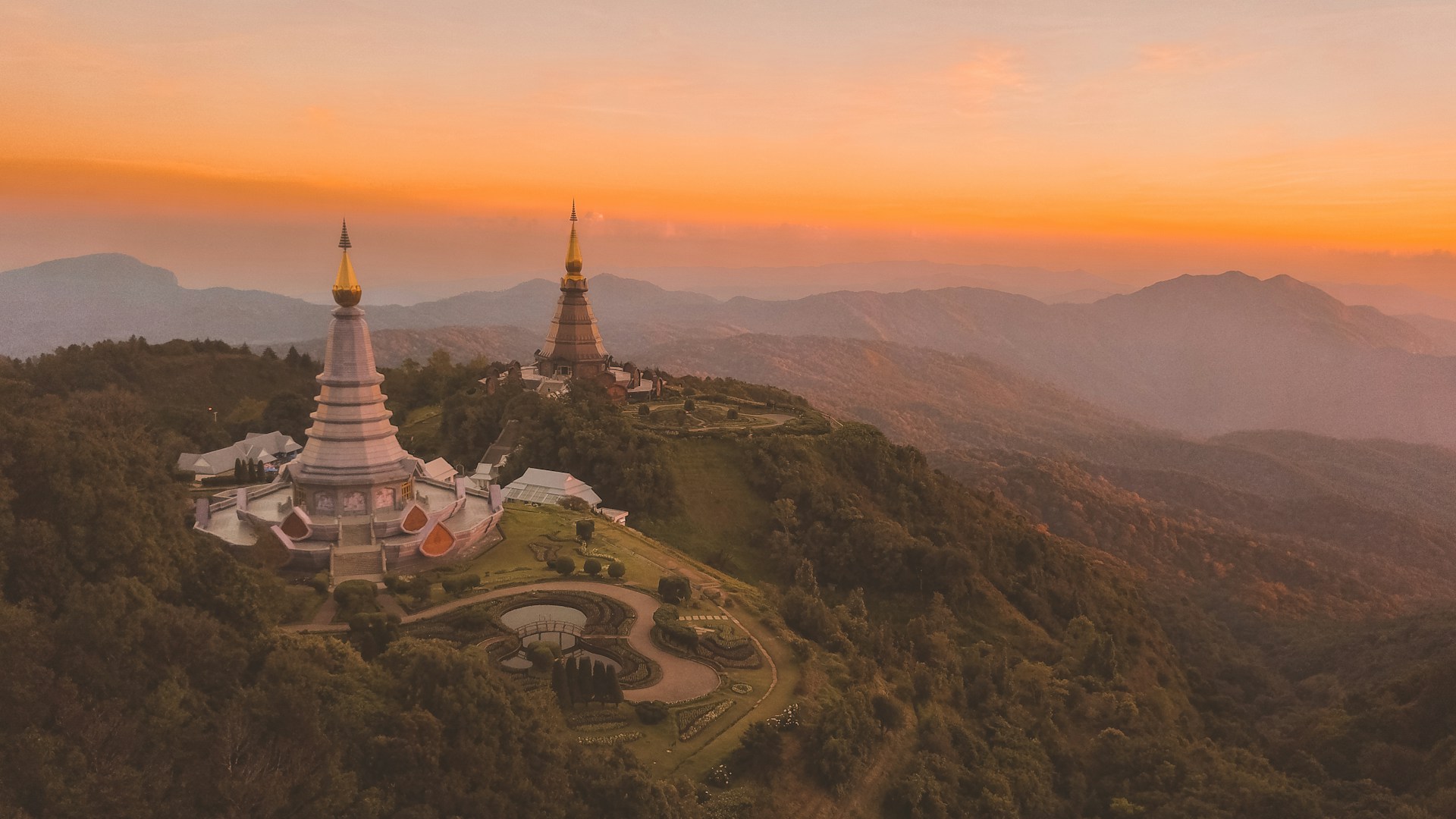
The Twin Pagodas (Phra Mahathat Naphamethinidon and Naphaphonphumisiri)
About 4 kilometers below the summit, two chedis sit on a ridgeline at around 2,200 meters elevation. They were built to honor the 60th birthdays of King Bhumibol Adulyadej and Queen Sirikit. The chedis are architecturally elegant, clad in purple-brown and grey-blue tiles respectively, and surrounded by manicured gardens with flower beds, trimmed hedges, and walkways.
The real attraction is the viewpoint behind them. On clear mornings, the panorama extends over a vast expanse of forested mountains fading into blue haze. The gardens themselves are meticulously maintained and pleasant to walk through, with flowering plants that bloom year-round. Entry to the pagoda grounds costs an additional 100 baht on top of the park admission.
Waterfalls
Doi Inthanon has several waterfalls, ranging from easily accessible roadside cascades to larger falls requiring short hikes.
| Waterfall | Height | Access | Highlights |
|---|---|---|---|
| Wachirathan | 70 meters | Short walk from car park | Powerful single drop, heavy mist spray, very accessible |
| Mae Ya | 250 meters | 20-minute drive off main road + short walk | One of Thailand's most beautiful waterfalls, multi-tiered cascade |
| Mae Klang | 100 meters | Near park entrance, easy walk | Wide cascade, popular swimming spot for locals |
| Siriphum | 40 meters | Viewable from the road near km 31 | Twin streams, scenic roadside stop |
| Mae Pan | Various | Along Kew Mae Pan trail | Encountered during the nature trail hike |
Wachirathan is the most visited because of its easy access and dramatic single-drop cascade that fills the air with cooling mist. Mae Ya is widely considered the most beautiful waterfall in Chiang Mai province but requires a detour off the main park road, so not all tours include it. If you have your own transport, do not skip Mae Ya.
Kew Mae Pan Nature Trail
This is the highlight of Doi Inthanon for hikers. The Kew Mae Pan trail is a 2.78-kilometer loop that follows a ridgeline through cloud forest and along exposed cliff edges with views over the valleys below. The scenery is stunning: gnarled rhododendron trees, orchids, moss-covered boulders, and on clear days, an ocean of clouds filling the valleys with mountain peaks poking through like islands.
Trail Details
| Detail | Information |
|---|---|
| Length | 2.78 km loop |
| Duration | 1.5-2.5 hours |
| Difficulty | Moderate (some steep sections, uneven terrain) |
| Guide required | Yes, mandatory. 200 baht per group (up to 10 people) |
| Starting point | Near the Twin Pagodas, km 42 |
| Season | Open November 1 to May 31. Closed June-October. |
A local guide is mandatory and costs 200 baht per group of up to 10 people. Guides are hill tribe members from nearby Karen and Hmong villages who know the trail intimately. They point out plants, birds, and viewpoints you would miss on your own. The trail is not technically difficult but includes some steep and slippery sections, especially after rain. Proper shoes with grip are essential.
The trail closes every year from June through October due to monsoon conditions. The best months for clear views are November through February, when the cool, dry weather produces the most dramatic cloud inversions.
Hill Tribe Villages and Coffee
Several Karen and Hmong hill tribe communities live within the park boundaries. Some villages operate small coffee plantations growing Arabica beans, which thrive in the cool highland climate. You can buy freshly brewed hill tribe coffee at stalls along the main road and near the summit for 30 to 60 baht per cup. The coffee is genuinely good, with a smooth, mild flavor that has attracted attention from specialty coffee buyers.
A few villages welcome visitors and sell handicrafts, textiles, and local produce. The interaction is low-key and respectful. These are working communities, not staged tourist villages.
How to Get There
Doi Inthanon National Park is about 70 kilometers southwest of Chiang Mai, roughly 90 minutes by car via Route 108 and then Route 1009 up the mountain.
- Organized day tour: The most popular option from Chiang Mai. Full-day tours typically include transport, the summit, Twin Pagodas, Wachirathan waterfall, and sometimes the Kew Mae Pan trail. Prices range from 800 to 2,000 baht per person depending on group size and inclusions. For transport options from Chiang Mai to Doi Inthanon and other northern Thailand attractions, check GoAsia.cc.
- Rent a car or motorbike: A car is the most comfortable option as the mountain road is winding with many stops spread over a long distance. Car rental in Chiang Mai starts at about 800 to 1,200 baht per day. Motorbikes work but the altitude makes for cold riding, and the road has steep sections.
- Songthaew from Chom Thong: Public songthaews run from Chom Thong market (at the base of the mountain) partway up the mountain road, but service is irregular and does not reach the summit. This is not practical for most visitors.
Practical Information
| Detail | Information |
|---|---|
| Park admission (foreigners) | 300 baht adults, 150 baht children |
| Twin Pagodas admission | 100 baht additional per person |
| Kew Mae Pan guide fee | 200 baht per group (up to 10) |
| Opening hours | Daily, 5:30 AM - 6:30 PM |
| Best season | November - February (cool, dry, clear views) |
| Summit temperature | 5-15 degrees Celsius (coldest December-January) |
| Distance from Chiang Mai | 70 km (about 90 minutes by car) |
Tips for Visiting Doi Inthanon
- Bring warm layers. This is not a suggestion you expect in Thailand, but the summit can drop below 10 degrees Celsius, and in December or January early mornings near freezing have been recorded. A fleece or light jacket is essential. If you are on a motorbike, add a windbreaker.
- Start early. Leave Chiang Mai by 6:00 to 7:00 AM to reach the park before clouds build up. Morning light is best for the Twin Pagodas viewpoint and the Kew Mae Pan trail. By midday, cloud cover often obscures the views.
- Do the Kew Mae Pan trail if it is open. This is the single best hiking experience accessible from Chiang Mai. If you visit between November and May, do not skip it. The guide fee is minimal and the scenery is extraordinary.
- Include Mae Ya waterfall. Many tour groups skip it because it requires a detour off the main road. If you have your own transport or can request it from your tour operator, Mae Ya is worth the extra time. It is arguably the most beautiful waterfall in northern Thailand.
- Wear proper footwear. The Kew Mae Pan trail, the Ang Ka boardwalk, and the paths around waterfalls can all be slippery. Trainers or hiking shoes with grip are important. Flip-flops are risky.
- Check the Kew Mae Pan trail status before going. The trail is closed from June through October every year. If the trail is your main reason for visiting, confirm it is open before making the trip.
- Try the hill tribe coffee. The Arabica coffee grown on Doi Inthanon is some of the best in Thailand. Stop at one of the roadside stalls near the summit for a cup. It makes a perfect warming drink in the cool mountain air.
- A full day is needed. Between the drive from Chiang Mai, the summit, Twin Pagodas, one or two waterfalls, and the Kew Mae Pan trail, a complete visit takes 8 to 10 hours. Do not try to rush it into a half day.
Frequently Asked Questions
Doi Inthanon is Thailand's highest mountain at 2,565 meters, located about 70 km southwest of Chiang Mai. The national park surrounding it offers cloud forest hiking, dramatic waterfalls, twin royal pagodas with mountain panoramas, and refreshingly cool temperatures that feel nothing like typical Thailand. It is one of the best day trips from Chiang Mai.
Park admission is 300 baht for foreign adults and 150 baht for children. The Twin Pagodas area costs an additional 100 baht per person. A mandatory guide for the Kew Mae Pan trail is 200 baht per group of up to 10 people. Organized day tours from Chiang Mai range from 800 to 2,000 baht per person including transport.
The park is about 90 minutes by car from Chiang Mai via Route 108 south to Chom Thong, then Route 1009 up the mountain. Most visitors join organized day tours or rent a car. Motorbikes work but the altitude makes riding cold. Public transport does not reliably reach the summit area.
November through February offers the best combination of cool weather, clear skies, and open trails. This is also when the Kew Mae Pan trail is open and cloud inversions create the most dramatic views. The park is accessible year-round, but the Kew Mae Pan trail closes June through October and monsoon rain can reduce visibility.
It is the single best hiking experience within day-trip distance of Chiang Mai. The 2.78 km loop follows a ridgeline through cloud forest with views over valleys often filled with clouds. A local guide is mandatory but costs only 200 baht per group. The trail is moderate in difficulty with some steep sections and takes 1.5 to 2.5 hours.
Summit temperatures typically range from 5 to 15 degrees Celsius year-round, with the coldest conditions in December and January when early morning temperatures can approach freezing. Bring a warm jacket or fleece regardless of when you visit. The temperature difference from Chiang Mai city can be 20 degrees or more.
Not really. Between the 90-minute drive each way, visiting the summit, Twin Pagodas, at least one waterfall, and ideally the Kew Mae Pan trail, you need a full day of 8 to 10 hours. Cutting the visit short means skipping major highlights. Leave Chiang Mai early in the morning and plan to return by late afternoon.
Mae Ya is widely considered the most beautiful waterfall in the park, and possibly in all of northern Thailand. It is a 250-meter multi-tiered cascade that requires a detour off the main park road. Wachirathan is the easiest to access and most dramatic with its powerful 70-meter single drop. If time allows, visit both.